Licensed surveying & cadastre (LİHKAB) services
Setting-out, change of land use, amalgamation, easements and on-site boundary indication as licensed office no. 3106-310.
Sahra Harita serves the whole of Hatay province as Licensed Surveying & Cadastre Engineering Office No. 3106-310, licensed by the General Directorate of Land Registry and Cadastre. The technical file for many land-registry transactions must be prepared by a licensed office: we take your application, survey on site and prepare the file for the cadastre directorate's approval.
Transactions we handle as a licensed office
Boundary setting-out
Marking parcel boundaries and corners on the ground according to land registry records.
Change of land use (cins değişikliği)
The technical file needed to register a new building on a parcel or to change the parcel's type (e.g. field to plot).
Amalgamation
Survey and computation file to register adjoining parcels as a single parcel.
Establishing or cancelling easements
Sketches required to create or remove easements such as right of way, water or power line rights.
On-site indication of a parcel or unit
Showing and reporting the location of a parcel or apartment on site, e.g. before a sale or in a dispute.
Correcting wrong unit or block numbers
Technical work to correct wrongly assigned apartment or block numbers in condominium records.
Determining cadastral road boundaries
Locating road boundaries shown on cadastral sheets on the ground.
Have these ready to speed things up
- Block / parcel number or a copy of the title deed
- Identity details of the owner(s)
- Power of attorney if the owner is not applying in person
- For a change of land use: occupancy permit and approved building project
- Zoning status or council decision from the municipality, if any
The exact list depends on the transaction and the property; we will tell you the full list when you call.
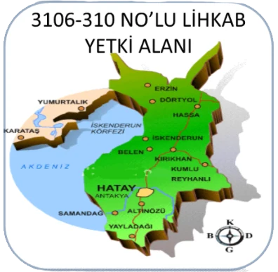
- Dörtyol
- Erzin
- Payas
- İskenderun
- Arsuz
- Belen
- Hassa
- Kırıkhan
- Kumlu
- Reyhanlı
- Antakya
- Defne
- Altınözü
- Samandağ
- Yayladağı
Work it out in advance
Area from coordinates
Type or paste corner coordinates from NetCAD or Excel and get area (m², dönüm, hectares), perimeter, edge lengths and a drawing instantly.
Open toolCadastre fee calculator
Estimated fees for setting-out, change of use, amalgamation and other licensed cadastre work, based on the official 2026 / 2. dönem tariff.
Open toolCommon questions
What is LİHKAB?
It stands for Licensed Surveying and Cadastre Engineering Office. Offices licensed by the General Directorate of Land Registry and Cadastre are authorised to prepare the technical files required for land-registry transactions. Sahra Harita's licence number is 3106-310.
Which areas do you serve?
For licensed cadastre work our authorised area is Hatay province, including Dörtyol, Erzin, Hassa, İskenderun, Payas, Arsuz, Belen, Kırıkhan, Antakya and other districts. For surveying, energy and consultancy we work throughout Turkey.
How much does a setting-out cost?
Fees for licensed cadastre work are set every year by the General Directorate of Land Registry and Cadastre. Send us your parcel details and we will tell you the total right away.
I have a boundary dispute with my neighbour. What should I do?
We recommend a boundary setting-out first, so that the real position of the parcel corners according to cadastral records is marked on site. The result provides a technical basis for an agreement or, if necessary, legal proceedings.
We can help with the other stages too
Surveying & Mapping
Base maps, topographic and strip maps; land readjustment, setting-out, GNSS surveys, as-built and industrial measurements.
Details 03Energy Projects (Solar & Wind)
Site selection, permits, zoning, expropriation and surveying for licensed and unlicensed solar and wind plants.
Details 04Construction & Contracting
Refinery and storage facilities, soil surveys, steel structures, raft foundations, installation, blasting & painting, electrical and automation.
Details 05Technical Consultancy
Design and construction supervision in industrial zones and OSBs, with an expert team of architects and engineers.
DetailsLet's talk about your project
Send us your parcel details or describe the job; we will reply with time and price the same day.